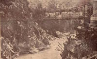
This is a single suspension bridge from the Bridgemeister historical inventory of suspension bridges.
Termas de Cauquenes
Termas de Cauquenes, Rancagua vicinity, Chile - Cachapoal River
| Bridgemeister ID: | 8165 (added 2024-02-03) |
| Name: | Termas de Cauquenes |
| Location: | Termas de Cauquenes, Rancagua vicinity, Chile |
| Crossing: | Cachapoal River |
| Coordinates: | 34.245472 S 70.553833 W |
| Maps: | Acme, GeoHack, Google, OpenStreetMap |
| Use: | Footbridge |
| Status: | Derelict (last checked: 2020) |
| Main Cables: | Wire |
| Suspended Spans: | 1 |
Notes:
- The coordinates provided here appear to be the location of the bridge in the associated image set. Satellite images (as of the 2000s) show what appears to be a derelict suspension bridge at this location crossing an arm of the Cachapoal River to reach a large outcropping.
- Near Termas de Cauquenes - Termas de Cauquenes, Rancagua vicinity, Chile.
External Links:
- Familia Claude sobre un puente colgante en Termas de Cauquenes, hacia 1920 - Memoria Chilena, Biblioteca Nacional de Chile. Image of the bridge dated 1920.
Image Sets:

Jochem Hollestelle contributed to the information and/or images for this bridge.
Do you have any information or photos about this bridge that you would like to share? Please email david.denenberg@bridgemeister.com.
Mail | Facebook | X (Twitter) | Bluesky