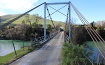
This is a single suspension bridge from the Bridgemeister historical inventory of suspension bridges.
1926: Lower Hurunui
North Canterbury, New Zealand - Hurunui River
| Bridgemeister ID: | 719 (added 2003-03-08) |
| Year Completed: | 1926 |
| Name: | Lower Hurunui |
| Location: | North Canterbury, New Zealand |
| Crossing: | Hurunui River |
| Coordinates: | 42.907226 S 173.273596 E |
| Maps: | Acme, GeoHack, Google, OpenStreetMap |
| Principals: | H.F. Toogood |
| References: | GAP |
| Use: | Vehicular (one-lane) |
| Status: | In use (last checked: 2024) |
| Main Cables: | Wire (steel) |
| Suspended Spans: | 1 |
| Main Span: | 1 x 65 meters (213.3 feet) estimated |
Notes:
- GAP: Refurbished, 1983.
- Not entirely clear the bridge described in GAP as the "Lower Hurunui" bridge near the mouth of the Hurunui is the same bridge as the present day bridge carrying Blythe Road. The detailed description of the 1926 bridge does not seem to match the current structure. However, Thornton also implied major changes to the bridge during the 1983 refurbishment.
External Links:
Image Sets:

Do you have any information or photos about this bridge that you would like to share? Please email david.denenberg@bridgemeister.com.
Mail | Facebook | X (Twitter) | Bluesky