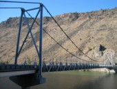
This is a single suspension bridge from the Bridgemeister historical inventory of suspension bridges.
1963: Crooked River
Opal Springs vicinity, Oregon, USA - Crooked River at Lake Billy Chinook
| Bridgemeister ID: | 216 (added before 2003) |
| Year Completed: | 1963 |
| Name: | Crooked River |
| Location: | Opal Springs vicinity, Oregon, USA |
| Crossing: | Crooked River at Lake Billy Chinook |
| Coordinates: | 44.528882 N 121.264512 W |
| Maps: | Acme, GeoHack, Google, OpenStreetMap |
| References: | GBD, WOT |
| Use: | Vehicular (two-lane, heavy vehicles) |
| Status: | In use (last checked: 2017) |
| Main Cables: | Wire (steel) |
| Suspended Spans: | 1 |
| Main Span: | 1 x 141.4 meters (464 feet) |
Notes:
External Links:
Image Sets:

Eric Sakowski contributed to the information and/or images for this bridge.
Do you have any information or photos about this bridge that you would like to share? Please email david.denenberg@bridgemeister.com.
Mail | Facebook | X (Twitter) | Bluesky