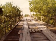
This is a single suspension bridge from the Bridgemeister historical inventory of suspension bridges.
1906: Tin Top
Tin Top, Texas, USA - Brazos River
| Bridgemeister ID: | 119 (added before 2003) |
| Year Completed: | 1906 |
| Name: | Tin Top |
| Also Known As: | Hightower Valley |
| Location: | Tin Top, Texas, USA |
| Crossing: | Brazos River |
| Coordinates: | 32.575956 N 97.822697 W |
| Maps: | Acme, GeoHack, Google, OpenStreetMap |
| Principals: | Mitchell & Pigg |
| References: | BRAZ, HAERTX98 |
| Use: | Vehicular |
| Status: | Collapsed, Jan. 31, 1982 under weight of snow |
| Main Cables: | Wire (steel) |
| Main Span: | 1 x 121.9 meters (400 feet) |
Notes:
- Some internet resources suggest the "Tin Top" and "Hightower" suspension bridges were separate nearby structures, however, this does not appear to have been the case. Both names were used to describe the same structure and USGS topographical maps from the 1950s label the bridge due south of Tin Top as "Hightower". Mitchell and Pigg did build a similar structure, at Brannon's Crossing. The 2015 National Register of Historic Places Registration Form for "Historic Road Infrastructure of Texas, 1866-1965", the Texas Department of Transportation writes: "In 1905 [Mitchell and Pigg] constructed the practically identical Brannon's Crossing and Hightower Valley Bridges across the Brazos in Parker County. The former was a 440-foot clear span while the later, also known as Tin Top, was 400 feet."
- The coordinates appear to be the exact location of a pier remaining (as of 2020) from this bridge. The alignment indicated by the pier appears to exactly match the location of this bridge as indicated by 1958 USGS topographical map of the area.
- Similar to 1906 Brannon's Crossing - Weatherford vicinity, Parker County, Texas, USA.
Image Sets:

Marjorie Campbell and Stephen Taylor contributed to the information and/or images for this bridge.
Do you have any information or photos about this bridge that you would like to share? Please email david.denenberg@bridgemeister.com.
Mail | Facebook | X (Twitter) | Bluesky